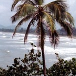
 The Kingdom of Sikkim which was not a part of India decided to merge its state with the Indian Republic in the year 1975. With that decision, India got a gift of a beautiful hill station know as Gangtok, capital of the Himalayan state of Sikkim. The journey to this stunning place is equally beautiful and 90% of the road is by the side of the river Teesta. The Kingdom of Sikkim which was not a part of India decided to merge its state with the Indian Republic in the year 1975. With that decision, India got a gift of a beautiful hill station know as Gangtok, capital of the Himalayan state of Sikkim. The journey to this stunning place is equally beautiful and 90% of the road is by the side of the river Teesta.
Continue reading Gangtok
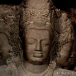 About 10 kilometers to the east of Mumbai, lies the island of Elephanta. A true example of Hindu cave culture, it consists of seven caves which can be divided into two groups. The first is a large group of 5 Hindu caves while the second is a smaller group of two Buddhist caves. The Hindu caves are the glorious abode of Lord Shiva. Nominated as a UNESCO World Heritage Site in 1987, this unique island is not only a worthy destination in itself, but it also provides a great view of Mumbai’s skyline and is a perfect escape from the chaos of the city. About 10 kilometers to the east of Mumbai, lies the island of Elephanta. A true example of Hindu cave culture, it consists of seven caves which can be divided into two groups. The first is a large group of 5 Hindu caves while the second is a smaller group of two Buddhist caves. The Hindu caves are the glorious abode of Lord Shiva. Nominated as a UNESCO World Heritage Site in 1987, this unique island is not only a worthy destination in itself, but it also provides a great view of Mumbai’s skyline and is a perfect escape from the chaos of the city.
Continue reading Elephanta Caves
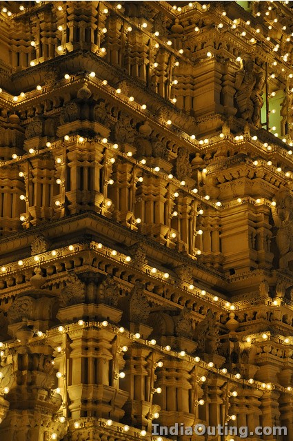
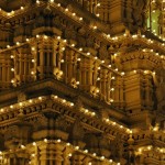 Mysore Palace or Mysore Maharaja Palace is one of the largest and most spectacular monuments in the country. Also known as Amba Vilas, it is located in the heart of the city of Mysore. The palace was initially built by the Wodeyar kings in the 14th century. Unfortunately, as it was made of out wood it got burnt down in 1897 during a royal wedding. The current palace construction was commissioned in 1897 and was completed by 1912. Designed by the famous British architect, Henry Irwin, it was built for the twenty-fourth Wodeyar Raja. It was the residence of the Wodeyar Maharaja’s of the Mysore State. Mysore Palace or Mysore Maharaja Palace is one of the largest and most spectacular monuments in the country. Also known as Amba Vilas, it is located in the heart of the city of Mysore. The palace was initially built by the Wodeyar kings in the 14th century. Unfortunately, as it was made of out wood it got burnt down in 1897 during a royal wedding. The current palace construction was commissioned in 1897 and was completed by 1912. Designed by the famous British architect, Henry Irwin, it was built for the twenty-fourth Wodeyar Raja. It was the residence of the Wodeyar Maharaja’s of the Mysore State.
Continue reading Mysore Palace
 Sariska Tiger Reserve is a national park which lies in the Alwar district of Rajasthan state of India. In the pre-independence period the forests within the Reserve were maintained as a hunting reserve area for the royalty of the former Alwar State. After independence, it got the status of wildlife reserve in the year 1955 when it became unlawful to hunt, shoot, net, trap, snare, capture or kill any kind of wild animals. It was promoted to a Sanctuary in 1958 and finally became a Tiger reserve in the year 1978 making it a part of India’s Project Tiger scheme. Sariska Tiger Reserve is a national park which lies in the Alwar district of Rajasthan state of India. In the pre-independence period the forests within the Reserve were maintained as a hunting reserve area for the royalty of the former Alwar State. After independence, it got the status of wildlife reserve in the year 1955 when it became unlawful to hunt, shoot, net, trap, snare, capture or kill any kind of wild animals. It was promoted to a Sanctuary in 1958 and finally became a Tiger reserve in the year 1978 making it a part of India’s Project Tiger scheme.
Continue reading Sariska Tiger Reserve
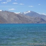 If you’re a fan of adventure, then Ladakh is the place for you. One of the most exciting ways to explore the landscape wonders as well as the remote areas of Ladakh. Crossing the Khardungla pass, considered to be one of the highest motor able roads in the world is a high like never before. Moreover, Ladakh is also a paradise for trekking and mountaineering due to its high peaks and mountains. You can also take part in and enjoy a number of fairs and festivals like the Losar festival, Hemis, Ladakh festival and tak-tok festival. If you’re a fan of adventure, then Ladakh is the place for you. One of the most exciting ways to explore the landscape wonders as well as the remote areas of Ladakh. Crossing the Khardungla pass, considered to be one of the highest motor able roads in the world is a high like never before. Moreover, Ladakh is also a paradise for trekking and mountaineering due to its high peaks and mountains. You can also take part in and enjoy a number of fairs and festivals like the Losar festival, Hemis, Ladakh festival and tak-tok festival.
Ladakh is a part of Jammu & Kashmir in the north of India. It consists of two districts Leh and Kargil.
Continue reading Leh Ladakh
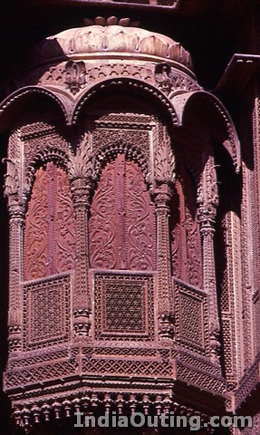
 Jaisalmer, also known as “The Golden City” is a town in Rajasthan. It was once known as Jaisalmer state and is the administrative headquarters of the Jaisalmer district. It’s not a very large town, with a population of about 78,000. However, it has a charm of its own and is a paragon of beautiful culture and harsh climatic conditions. Jaisalmer is named after Maharawal Jaisal Singh who founded the city. He was a Rajput king in 1156 AD. “Jaisalmer” means “The hill fort of Jaisal”. Continue reading Jaisalmer Jaisalmer, also known as “The Golden City” is a town in Rajasthan. It was once known as Jaisalmer state and is the administrative headquarters of the Jaisalmer district. It’s not a very large town, with a population of about 78,000. However, it has a charm of its own and is a paragon of beautiful culture and harsh climatic conditions. Jaisalmer is named after Maharawal Jaisal Singh who founded the city. He was a Rajput king in 1156 AD. “Jaisalmer” means “The hill fort of Jaisal”. Continue reading Jaisalmer
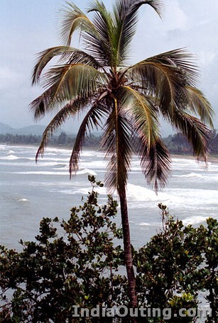
 Gokarna is a village in Karnataka, in the district of Uttara Kannada of Karnataka state. Gokarna literally means “Cow’s ear”. It is believed that Lord Shiva emerged from the ear of a cow here. Hence it is also known as the temple town and is an important pilgrimage center for the Hindus. Another probable reason for the name Gokarna could be due to its Geographical location. The area where it is located is the convergence of rivers Gangavali and Agnashini and resembles the shape of a cow’s ear. Continue reading Gokarna Gokarna is a village in Karnataka, in the district of Uttara Kannada of Karnataka state. Gokarna literally means “Cow’s ear”. It is believed that Lord Shiva emerged from the ear of a cow here. Hence it is also known as the temple town and is an important pilgrimage center for the Hindus. Another probable reason for the name Gokarna could be due to its Geographical location. The area where it is located is the convergence of rivers Gangavali and Agnashini and resembles the shape of a cow’s ear. Continue reading Gokarna
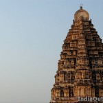 Also known as Humpi or Hampe, Hampi is a small village situated in Northern Karnataka. It was the capital of the Hindu empire, Vijayanagara, who ruled south India from 14th to 16th century AD. With the help of his devotee disciples Hakka and Bukka, Saint Vidyaranya established the base of Vijayanagara Empire in 1336 AD. It gained popularity because of its re-establishment of Indian culture and its support for music, art and literature. They also encouraged the renovation and reconstruction of temples throughout India. With their main focus being on caring for the people and their welfare, this empire soon spread from Karnataka to Andhra Pradesh and Maharashtra as well. Also known as Humpi or Hampe, Hampi is a small village situated in Northern Karnataka. It was the capital of the Hindu empire, Vijayanagara, who ruled south India from 14th to 16th century AD. With the help of his devotee disciples Hakka and Bukka, Saint Vidyaranya established the base of Vijayanagara Empire in 1336 AD. It gained popularity because of its re-establishment of Indian culture and its support for music, art and literature. They also encouraged the renovation and reconstruction of temples throughout India. With their main focus being on caring for the people and their welfare, this empire soon spread from Karnataka to Andhra Pradesh and Maharashtra as well.
Continue reading Hampi
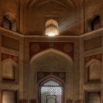 Located in Nizamuddin East, Delhi, Humanyun’s tomb is the tomb of the Mughal Emperor Humayun. He passed away in 1556 and his wife Hamida Banu Begam supervised the construction of his tomb from the year 1562. This spectacular piece of architecture took almost 9 years to complete. Humayun was the second Mughal Emperor to rule India, after his father, Babur being the first. Located in Nizamuddin East, Delhi, Humanyun’s tomb is the tomb of the Mughal Emperor Humayun. He passed away in 1556 and his wife Hamida Banu Begam supervised the construction of his tomb from the year 1562. This spectacular piece of architecture took almost 9 years to complete. Humayun was the second Mughal Emperor to rule India, after his father, Babur being the first.
Continue reading Humayun’s Tomb
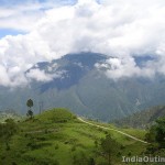 Situated at an altitude of 1869 meters above the sea level, this idyllic hill station is located just 59kms away from Nainital. It was discovered and built entirely by the British in 1869. The serene hills, the blooming valleys, the pleasant climate will cast an instant spell on the visitor. Situated at an altitude of 1869 meters above the sea level, this idyllic hill station is located just 59kms away from Nainital. It was discovered and built entirely by the British in 1869. The serene hills, the blooming valleys, the pleasant climate will cast an instant spell on the visitor.
Continue reading Ranikhet Hill Station
|
|